
Climate Nexus Press advisory:
Cyclone Chapala—a rare Middle Eastern cyclone—is poised to make landfall in Yemen as a Category 1 or 2 storm early Tuesday morning. It brings a dangerous storm surge, torrential rain, flooding and mudslides to Mukalla, a coastal city of 300,000 people who have likely never experienced a storm of this magnitude. It has already taken three lives in Socotra, an island 368 km off Yemen’s coast.
If predictions prove correct, Chapala will be the first ever hurricane-strength cyclone on record to hit Yemen and has the potential to cause significant damage and loss of life. The eye of Chapala will likely pass 50 miles south of Mukalla, producing a two meter storm surge and 500mm (20 in) of rainfall in a 48 hour period, five times greater than its average rainfall over an entire year, 100mm (4in).
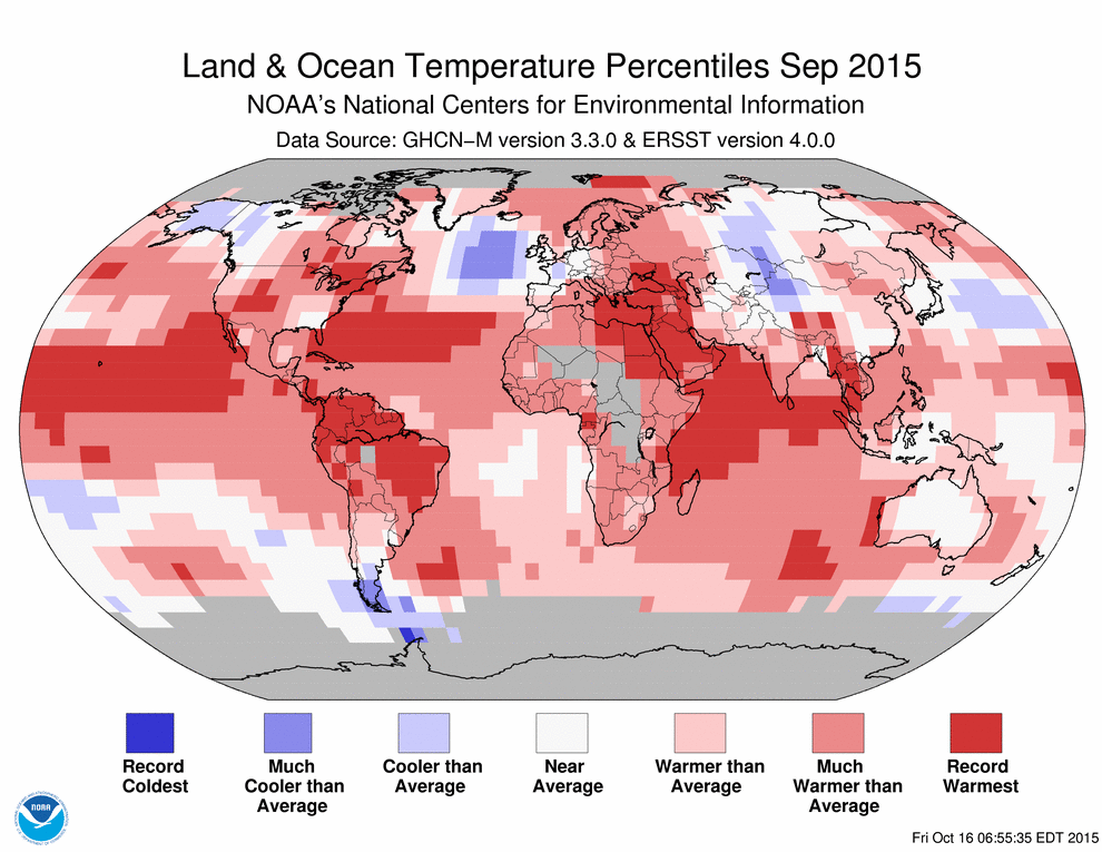
Cyclone Gonu in 2007 is the only hurricane-strength cyclone in modern records to affect the Arabian Peninsula, and there are only four observations in the scientific literature of tropical storm surge or storm tide in the Arabian Sea. Chapala is fed by record warm ocean temperatures fueled by an extreme El Niño and boosted by global warming.
As stated by Bob Henson at Weather Underground, “It is difficult to overstate the rarity and gravity of this event: a hurricane-strength storm striking near a large, ancient city, situated near mountains, with no modern experience in dealing with tropical cyclones. Although Hurricane Patricia got much more media attention, Chapala may end up bringing more damage and misery by far.”
For more detailed information on how climate change impacts hurricanes, see Climate Nexus’ Hurricane backgrounder.
- Sea surface temperatures along the path of Cyclone Chapala are at record levels.
- Climate projections show a substantial 46 percent increase in cyclone frequency over the Arabian Sea by the end of the century.
- Climate change loads hurricanes with additional moisture, intensifying rainfall and raising the risk of flooding.
- There is strong evidence that climate change increases the frequency of the most intense cyclones, the winds of which incur exponentially greater damage compared to lesser cyclones.
- Due to the combined impact of an extreme El Niño and climate change, 2015 has been a record year for tropical cyclones in the Northern Hemisphere.
Cyclone Chapala is headed for an extremely rare landfall at hurricane strength along the coast of war-torn Yemen late Monday or early Tuesday (mainland U.S. time). While wind damage will be a threat near the point of landfall, the bigger concern will be extremely heavy rainfall in a normally arid region, leading to life-threatening flash floods in a country already suffering a major humanitarian crisis stemming from years of violent conflict.
The eye of Chapala has already passed by Socotra, just to the north of the island, where flooding rain and damaging winds were reported. The island has likely not experienced a cyclone of hurricane-equivalent intensity since 1922.
Chapala was a Category 2 equivalent storm on the Saffir-Simpson Hurricane Wind Scale as of Monday evening (mainland U.S. time). It had rapidly intensified to a high-end Category 4 early Friday and remained in that Category through most of Saturday. This made Chapala the strongest tropical system so far south in the Arabian Sea on record.
Note in Yemen, due to their low rainfall (average 2″ per annum, much of their building including ancient multi story is mud brick.
extensive flooding and multi story mud brick cities do not make good bedfellows
Ho-hum—move on, folks—-nothing to see here.
Except what looks to be the “new normal”. Get ready for 2016.
“The Arabian Sea cyclone also padded the current record for the highest number of tropical cyclones with winds equivalent to a major hurricane (115+ MPH) ever recorded in the Northern Hemisphere. We’ve seen 27 such storms this year, which, according to Dr. Philip Klotzbach, dwarfs the previous record of 20 held by the active years of 1997 and 2014”