“Where climate change gets you most, is when you take a 150 year event, and then it suddenly becomes a 50 year event” – Prof Kerry Emanuel of MIT, and others, explain above.
In Ida’s remains, disaster keeps reverberating.
Jeff Masters in Yale Climate Connections:
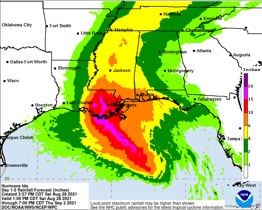
The remnants of two hurricanes will drench separate parts of the United States from Tuesday into Wednesday, with significant flood risk in both cases. The main concern is with Tropical Depression Ida, as the storm migrates northeast and gradually merges with a pre-existing front from the Ohio Valley across southern New England, becoming post-tropical by Thursday morning. Moist tropical flow from the south toward Ida will help strengthen the front, while the location of an upper-level jet will favor rising motion near the frontal zone. Upslope flow into the higher terrain of the Appalachians will further accentuate the rainmaking potential. Moreover, soils are unusually wet across much of Tennessee and eastern Kentucky, and from eastern Pennsylvania and New Jersey across southern New England, in the wake of two earlier tropical cyclones, Fred and Henri.
NOAA’s Weather Prediction Center has tagged a belt from near Atlanta to near Pittsburgh with a Day 1 moderate risk (the second-highest of four risk levels) of excessive rain leading to flooding, through Tuesday night. There is also a moderate risk for parts of southern Arizona, where moisture streaming in from former Hurricane Nora may cause heavy showers and thunderstorms. Nora hit Mexico near Puerto Vallarta on Sunday as a category 1 hurricane, causing heavy damage.